Medium to Long Range weather/local climate forecasting a new approach by Dr Chris Barnes, Manager, Bangor Scientific and Educational Consultants, LL57
Dr Barnes Homepage http://www.drchrisbarnes.co.uk
E-MAIL doctor.barnes@yahoo.co.uk
Abstract
The present author has recently developed a new method for Medium to Long Range weather/local climate forecasting, patent applied for, based on the behaviour of the so called QBO ( quasi-biennial oscillation). Since the QBO originates in the stratosphere it will have intimate coupling with solar and atmospheric electricity and chemistry drivers but it is also known to have coupling with ENSO and the AO/NAO semi annual oscillation systems of the Northern Hemisphere. The present author has further shown via a special algorithm or set of algorithms ( detail presently confidential) that the QBO is a sensitive barometer of UK weather and climate anomaly and even predictor of extreme weather events. Whereas due to Confidentiality the nature of the Data sets employed in addition to the algorithms cannot presently be released it is important to emphasise the predictive abilities of this method. A data input set ending in either 2011 or 2012 perfectly produces this February ( 2014) EXTREME WEATHER EVENT! Positive QBO can lead to the most extreme weather events in both winter rainfall and short-lived summer temperature excursions. As far as has been possible due to Confidentiality restrictions a brand new and relatively simple approach to Medium to Long Range weather and local climate forecasting is demonstrated to work. Further investigation into contrail forecasting will however be useful. Once the patent application is published in the public domain full details will be released. With the benefit of improved forecasting methods for extreme weather events, Britain will be better prepared to protect itself.
Introduction
Weather and climate forecasting typically make use of vast numerical models. Such models require inputs from satellites, ground observations, balloons, radars , atmospheric sounders and the like. Short term weather forecasts tend to be easier to make because one can watch the behaviour and track of weather systems in the troposphere by ground reports and by satellite. Even these can go horribly wrong, the great storm of 1987 which demolished Sevenoaks' famous trees is an event many of us will recall or will have learned about.
Longer term prediction and modelling is notoriously more difficult. This is because there are so many different climate models and cloud parameterisation models and because coupling between the various parts of the atmosphere is still not fully understood. It is the present author's view point that no part of the atmosphere or the planetary wave systems and other energy and momentum transfer systems within it can be viewed in isolation. Thus any model which attempts to simulate the entire atmosphere would appear horrendously and almost prohibitively complex. Since there are so many non-linear energy transfer processes in the atmosphere, the slightest misrepresentation in parameterization of a model can render the entire model next to useless. An example of this possibly occurred during Met Office predictions for South West Britain for the Winter of 2013/14 whereas Somerset was predicted to be drier than average but the very opposite has turned out to be true with the attendant catastrophic loss of homes, farms, land and livelihood for those affected.
The present author has recently developed a new method for Medium to Long Range weather/local climate forecasting, patent applied for, based on the behaviour of the so called QBO ( quasi-biennial oscillation). Since the QBO originates in the stratosphere it will have intimate coupling with solar and atmospheric electricity and chemistry drivers but it is also known to have coupling with ENSO and the AO/NAO semi annual oscillation systems of the Northern Hemisphere. The present author has further shown via a special algorithm or set of algorithms ( detail presently confidential) that the QBO is a sensitive barometer of UK weather and climate anomaly and even predictor of extreme weather events. Whereas due to Confidentiality the nature of the Data sets employed in addition to the algorithms cannot presently be released it is important to emphasise the predictive abilities of this method. A data input set ending in either 2011 or 2012 perfectly produces this February ( 2014) EXTREME WEAHTER EVENT!
Results
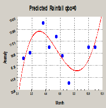
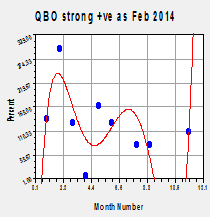
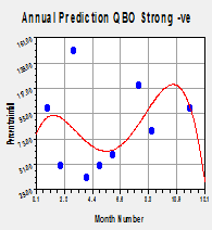
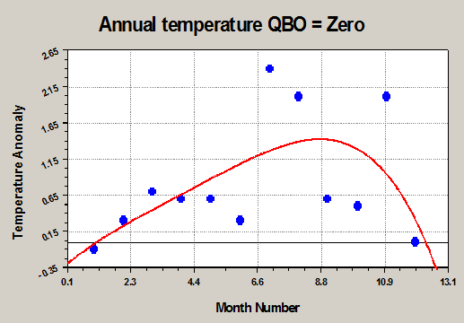
The purpose of this short paper is to show results ( without detail due to confidentiality constraints) indicating how different QBO scenarios might influence UK annual weather in this case the local Welsh Climate in a predictive manner. A forecast has been produced for temperature, rainfall, gales, sunshine and persistent contrails. Results have been produced for three different scenarios with QBO strongly negative, QBO = ZERO and QBO strongly positive based on previously observed maxima of equatorial winds ( precise data not shown due to confidentiality). At present QBO is positive ( Westerly) and expected to remain so possibly for between 1 and 2 years.
Results rainfall.
The rainfall results have been published elsewhere but have been included
The results are intriguing. QBO =zero seems to equate with the typical UK year April Showers scenario. Further the QBO close to zero scenario is probably thus what spurned the lesser known weather rhyme:
When
April Sounds aloud his horn,
Great crops will be of hay and corn
April's horn being 'Thunderstorms' associated with April showers.
QBO strong -ve indicates a dry spring and Summer but with a wet autumn. QBO strong +ve indicates a deluge February followed by a normal March, a very dry April, a potentially wet July and a dry August/September. It can clearly be seen in this scenario most rain falls in the period January to March especially February. This is the exact scenario the UK has just experienced and possibly the historic true origin of the weather lore phrase 'February fill-dike', rather than the dikes being filled by snow melt, they may have also many years in the past being filled with heavy February rains not unlike this years' scenario. The correlation factor is reduced mainly as a result of three major residuals are greatest in February, April and July where most extreme and random fluctuation weather events might be to be expected.
Temperatures
The purpose of the of this present paper is to extend such prediction to cover an entire year and also to take on board features beyond rainfall such as temperature anomaly and sunshine anomaly, the latter could also be regarded as a measure of reduced cloudiness.
The model can also be used to test the effect of minimal or gently reversing zonal wind as in the case of the summer of 1976 and to predict the likelihood of the distinct scenarios of more slowly continuing and rapidly fluctuating extreme weather events as well as to examine worst case scenarios. Our ancestors would have statistically experienced the bulk of such scenarios which are, given the growing body of evidence that all so called ‘internal’ atmospheric waves are solar driven, by no means new. It is the present contention that it is from the experience such scenarios our present weather ‘sayings’ may have come about. We are, however, brought up in Britain to expect for example February ‘fill-dike’ to be followed by March winds, April showers and a ‘Flaming’ June.
However, closer examination of weather Folk Lore tends to suggest this should not necessarily be the case. It would seem more likely at least some the sayings came about as a result of extreme or unusual scenarios rather than the norm. For example February fill-dike has commonly said to be associated with snow melt but maybe it was really associated with extreme rainfall events with QBO strongly positive as is the present trend. This is perhaps why there are so many specific additional sayings detailing individual dates or parts of months. Some examples are given below:
When
April Sounds aloud his horn,
Great crops will be of hay and corn
St.
Luke's summer
In
English folklore, a period of fine, calm weather, similar to Indian
summer, occurring in October.
St.
Martin's summer
In
English folklore, a period of fine, calm weather, similar to an
Indian summer, occurring in November.
St.
Swithin's Day
St.
Swithin's Day, if thou dost rain,
For forty days it will remain
St. Swithin's Day, if thou be fair
For forty days 'twill rain
nae mair”
In
English folklore, a day that is popularly supposed to govern the
weather of the succeeding 40 days; specifically, if it rains on St.
Swithin's Day, 15 July, it will continue to rain for 40 days.
“If
Bartlemas Day [August 24] be fine and clear
Then a prosperous
autumn comes that year”
The models develop herein will also be used to explore validity, if any, in these sayings.
Discussion of temperature predictions
The QBO zero case shows normal winter temperatures, gradually escalating spring and summer temperature anomaly peaking in August and September. Such a scenario is rare and last happened in Britain in 1976.
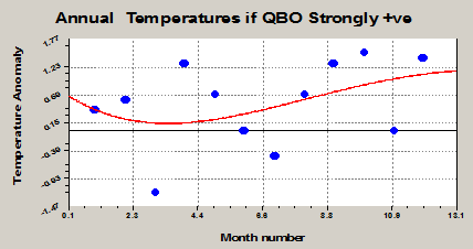
The QBO +VE case shows a potential for a normal or cold March followed by slowly increasing temperature anomaly peaking with an Indian Summer. The residuals are large suggesting potential extremes of heat in April and September taken with the rainfall anomaly a wet, thundery midsummer period is possible. If present QBO speeds do not slow this is the type of Summer on the cards for 2014.
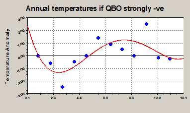
The QBO -VE scenario predicts very cold winters with the cold maximising in February and March, winter of 2013 was the most recent example. It further predicts a July heatwave, also experienced in 2013 although the QBO changed direction at about the same time.
Interestingly the models diverge on regression factor between rainfall and temperature. At zero QBO highly predictable rainfall events occur but extreme short-lived temperature events can also occur.
Positive QBO can lead to the most extreme weather events in both winter rainfall
and short-lived summer temperature excursions.
Negative QBO has quite predictive annual temperature functionality and winter rainfall but can give rise, according to the residuals, to summer extreme flooding events.
Sunshine anomaly (cloudiness)
No study of this type would be complete without a similar regression analysis on sunshine anomaly which ought to be reflective of certain, if not all, types of cloudiness.
The author has a special interest in contrail induced cloudiness and it will also be explored in the present context.
Sunshine Results
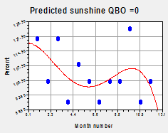
The sunshine result at QBO = 0 is almost consistent with the temperature and rainfall results.
April rainfall clouds bring a dip to the sunshine expected in that month. Settled warm weather in early autumn corresponds with a sunshine peak and colder than average January weather consistent with settled winter weather brings a winter sunshine peak also.
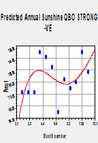
With QBO -VE the high autumn rainfall peak corresponds with the dip in sunshine as expected.
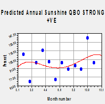
QBO +VE has been shown to produce the most unpredictable UK the narrow rainfall trough in late autumn is mirrored by the potential increase in sunshine but throughout a QBO strong +ve year sunshine amounts are, strangely, roughly average yet with significant sporadic short lived wild fluctuations.
Persistent Contrails
Others have commented on the QBO and global aerosol distribution. It might, then, be expected to influence persistent contrails over the UK. Contrails are a form of cloudiness so it will be interesting to compare the contrail and sunshine results.
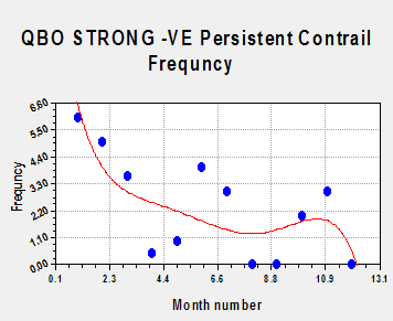
With
QBO -VE and in winter contrail frequency appears to be correlated
with cloudiness but not in summer. The author has previously remarked
on differences in atmospheric chemistry affecting persistent
contrails which appear at morning or night. Maybe there is a similar
Winter/ Summer split?
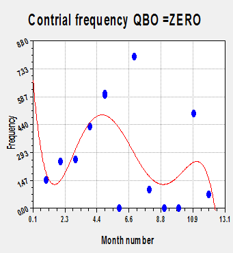
For QBO zero the contrail frequency is more or less anti-correlated with sunshine as expected yet it only correlates with autumn but not spring rainfall. Contrail behaviour against season clearly warrants far more investigation.
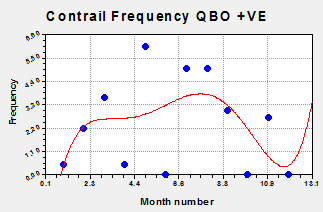
Again
with QBO +VE the con trial frequency is neither perfectly correlated
or anti-correlated
with any of the other climate anomaly indicators. Consistent for QBO +VE with the other indicators is the large degree of statistical fluctuation in the residuals. Contrails were locally rerecorded at the home of the author and being a subjective phenomenon often obscured by other cloud there is room for significant error.
Gales
The study is completed by examining gales. These too were recorded by the author.
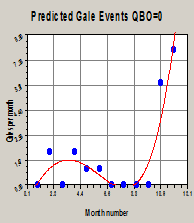
Judging by the lack of spread in the data, gale forecasting appears to be by far and above the most accurate climate indicator based on the current method.
For QBO zero the traditional equinox gales are present at the vernal equinox but delayed by over a month at the autumn equinox.
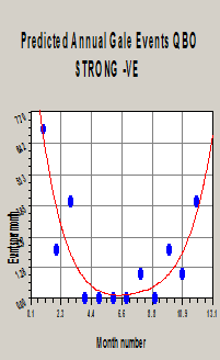
For QBO strong -ve winter gales appear to significantly outweigh equinox gales, although there are minor data residuals around month 3 and 9.
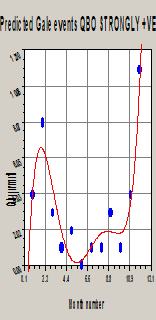
For QBO STRONG +VE the vernal equinox gales occur with roughly a tripled frequency and over a month early in February which is what we have experienced this winter. A minor data residual is also seen for the autumn equinox. No gales occur in summer suggesting that any extreme events will be of a thundery rain type. The extreme gale events in February combine with the extrema in rainfall events as just witnessed.
Conclusions
As far as has been possible due to Confidentiality restrictions a brand new and relatively simple approach to Medium to Long Range weather and local climate forecasting has been demonstrated to work. Once the patent application is published in the public domain full details will be released.
With the benefit of improved forecasting methods for extreme weather events, Britain will be better prepared to protect itself.